Join us for the Graduate GIS Programs Information Session May 7 at 12 p.m. PT Register Today
USC Dornsife Spatial Sciences Institute

Author Archives: actemplatestg

  1. Emerging GIS Technologies

    Comments Off on Emerging GIS Technologies

    Geographic Information Science and Technology (GIST) includes a versatile range of tools and techniques for capturing, analyzing and leveraging spatial information. With each passing year, advances in Geographic Information Systems (GIS) reveal new applications in urban planning, retail, space exploration, and more. Experts make the most of these opportunities by staying up to date as new ways of optimizing and employing GIS technology emerge.

    By implementing robust GIS software applications, professionals can capture and visualize valuable geospatial intelligence. That’s why it’s vital for GIST experts to possess the combination of theoretical knowledge and hands-on training that comes from attending a forward-looking online GIST graduate program. Here are some of the ways GIS technology is used to meet complex challenges, including a preview of some of the fascinating changes ahead:


    Open Source GIS Mapping Software Empowers Innovation

    Open-source GIS mapping software gives users access to powerful tools for creating maps and adding elements such as text, images and video. Particularly in conjunction with initiatives such as OpenStreetMap or the Open Geospatial Data Project, these applications offer endless possibilities for collecting and visualizing spatial information and customizing maps. Users create projects to:
    Construction worker using GIS tech

    • Highlight the demographics of a region
    • Trace the availability of natural resources over time
    • Chart crop growth and capture any evidence of disease
    • Demonstrate how changes in environmental conditions affect the preservation of a historical site

    The flexibility to assemble maps for diverse purposes has a growing impact in daily life, influencing progress in smart city infrastructure. With extensive locational data, government agencies and private businesses can deliver services more efficiently and strategize sustainable development. Customized maps may be applied to augmented reality projects that provide workers with helpful details tied to a specific location.

    Meanwhile, open-source mapping has a huge role in the burgeoning world of navigation systems and automated vehicles. When setting routes, these systems account for a widening range of factors, such as traffic conditions updated in real time and individual preferences. GIS is essential to improving performance in self-driving cars and guiding drivers to their destinations as quickly, comfortably and safely as possible.

    Request Brochure

    Fill out the information below to learn more about the University of Southern California’s GIS Graduate Programs and download a free brochure. If you have any additional questions, please call 213-325-2474 to speak to an enrollment specialist.

    University of Southern California has engaged AllCampus to help support your educational journey. AllCampus will contact you shortly in response to your request for information. About AllCampus. Privacy Policy. You may opt out of receiving communications at any time.

    * All Fields are Required. Your Privacy is Protected.

    Artificial intelligence

    Artificial intelligence is another rapidly evolving technology that has been applied to GIS projects in recent years. One important application for GeoAI is in planning urban infrastructure and tracking changes in an area over time.

    For example, researchers in Los Angeles wanted to know how land use and roadways impacted air pollution and, in turn, how pollution would affect health in local residents. GIS helped them analyze traffic patterns over different times of day in relation to the concentration of harmful particles in the air. By using this information to predict when pollution levels would become dangerous, the city could issue warnings as early as possible.

    In another project that utilized GeoAI, Kuwaiti government officials wanted to make it easier for citizens to find products and services they needed by using an application. Like many big cities, traffic congestion was a major obstacle, and the government wanted to be able to tell users what road conditions were like at any given time. The application gave users the ability to share whether they were seeing heavy, moderate or light traffic, which helped the researchers identify traffic patterns. When there was heavy traffic on one route, the application would deliver directions to avoid traffic jams.

    The application initially relied on user input and manual updates to identify traffic, requiring constant adjustments to the machine learning algorithm. With the introduction of GeoAI, the application gained a deeper understanding of traffic conditions and greater predictive capabilities, which in turn led more useful driving instructions.

    GeoAI is still evolving and has the potential to be one of the future trends in GIS that makes the biggest impact on daily life. In addition to land use and infrastructure analysis, GeoAI can also be applied to health systems, agriculture and many more industries.


    Fresh Insights from Geospatial Analytics

    The rise of big data and analytics has been one of the most significant shifts for businesses over recent years. Across industries, organizations are constantly seeking chances to turn an ever-increasing volume of data into a competitive edge, and many have found that GIST adds value to these efforts. Geospatial analytics applies geographic information to enable wiser decision-making and agile problem solving.

    With GIS data, analytics specialists can create visualizations, identify meaningful trends and make predictions, generating reports that flesh out valuable context for strategy. Decision-makers gain increased visibility from synthesizing spatial information with findings from enterprise resource planning (ERP) systems. They can clearly see how crucial data about their organizations is attached to specific times and places.

    Geospatial analytics clarifies complicated relationships and points out ways to streamline processes. Businesses and government agencies can:

    • Make more informed choices about building or expanding facilities and stores
    • Track when devices and equipment with Internet of Things (IoT) sensors enter or leave a work area
    • Create apps for retail customers that enrich their in-store experiences (e.g. retail beacon technology)
    • Speed up logistics and reduce costs by running various routing scenarios
    • Find patterns of criminal activity within a region
    • Minimize risks from hazardous location-based events like powerful storms

    Bringing Together GIS and Drones

    Organizations and consumers employ unmanned aerial vehicles (UAVs) for an ever-expanding list of applications, from entertainment to agriculture, often relying on navigation supported by GIS. For instance, experiments with making deliveries by drone have unlocked possibilities for getting food and other products to customers with unprecedented speed. Other companies are deploying the aircraft to collect information from IoT sensors that monitor industrial sites, hazardous travel conditions, volatile weather patterns or the wellbeing of crops and send real-time updates.

    Meanwhile, drones also improve the information that is available for mapping and manipulation with GIS tools. A great deal of spatial data comes from satellite imagery and readings taken by manned aircraft, but drones are a cost-effective means of gathering extensive details on a smaller scale. UAVs thus have a major role to play in making geographic information more readily available for open-source mapping and customizable to fit the priorities of businesses, governments, independent researchers and hobbyists.


    Real-time data

    The ability to collect and analyze data in real time brought GIS to a whole new level. This development improved research processes and mapping systems, but real-time geospatial data can benefit consumers, too.

    Location-based services like Uber are among the most common uses for up-to-the-minute geographic information. Consumers can track where their drivers are and how long it’ll take them to arrive. The app also employs real-time data to match users with the closest ride and directs drivers to hot spots based on the frequency of ride requests.

    Real-time geospatial intelligence can also be an effective way to track developments during natural disasters. Analysis of everything from shifting weather patterns to social media posts highlight locations in urgent need of relief efforts. Emergency management services use GIS platforms to generate crisis maps based on a combination of:

    • Satellite imagery
    • Remote sensor readings
    • Statistical models
    • Crowdsourced data

    When facing time-sensitive decisions, it is important to have the most relevant and accurate data. Robust geographic information is a boon to organizations and individuals striving to make well-informed decisions, and ongoing refinements to real-time data analysis are vital to the future of GIS.


    Consumer-facing information

    Geospatial data has helped companies in a wide range of industries streamline their operations by providing greater visibility into key assets and guiding more efficient supply chains. But everyday consumers can also take advantage of current trends in GIS. Some of the latest GIS technology has brought consumer-facing data to the forefront, empowering smart decisions in many areas.

    Consider homebuying: A house might be in your price range, but the neighborhood can make all the difference in whether it’s the right choice for your family. That’s why real estate apps now use GIS platforms to give prospective homebuyers insights into the areas they’re considering. Dozens of map layers let users review details like distance to various amenities, school district information and more. People aren’t just looking at photos on home search websites anymore; they’re scouring details about what it feels like to live in an area.

    The health and wellness industry underwent a major shift in recent years with many consumers applying data to manage their own lifestyles. Wearable technology lets individuals track their heartrate, steps, sleep patterns and the paths they follow when running or walking. With geospatial information, personal fitness goals become more attainable, and these advances have even made a mark in college and professional sports: Coaches can factor the personal data from players’ GPS-enabled wearables into their strategic decisions, snagging victory while minimizing the chance for injury.


    What’s Next for GIST?

    For professionals with expertise in spatial technology and problem solving, the future looks rich in possibilities. In the years ahead, GIST will likely become an even more prevalent aspect of our daily lives, thanks in large part to the widespread adoption of smart technology and the IoT. As sensors capable of sharing spatial-temporal information appear everywhere from industrial equipment to coffeemakers, the volume of spatial data will grow exponentially.

    Meanwhile, consumers and businesses will demand greater functionality and integration from spatial software applications. Ride sharing services and navigation apps have shown the public the power of apps that work with GPS and mapping platforms to give them real-time updates. These types of features could have growing uses for enterprises and governments as well when harnessed for purposes such as tracking assets and growing the reach of marketing campaigns.

    The proliferation of spatial data and market for software means organizations will have a mounting need for professionals familiar with every layer of the GIS Technology stack. Data specialists will need to optimize their processes for collecting, cleaning and formatting spatial information. GIS software developers must also understand the full scope of the data resources they have available for creating spatial-powered apps to put that information to work.


    About USC’s GIS Graduate Programs

    The University of Southern California offers a comprehensive selection of online and residential GIS programs. This includes both GIS master’s degrees and GIS graduate certificates. Click on the programs below to learn about our leading geographic information science education.

    GIS Master’s Degrees

    GIS Graduate Certificates


    Request Brochure

    Fill out the information below to learn more about the University of Southern California’s GIS Graduate Programs and download a free brochure. If you have any additional questions, please call 213-325-2474 to speak to an enrollment specialist.

    University of Southern California has engaged AllCampus to help support your educational journey. AllCampus will contact you shortly in response to your request for information. About AllCampus. Privacy Policy. You may opt out of receiving communications at any time.

    * All Fields are Required. Your Privacy is Protected.

  2. Your Guide to Professional Graduate GIS Certifications

    Comments Off on Your Guide to Professional Graduate GIS Certifications

    GIS certifications validate an individual’s knowledge and skills within specific areas of GIS such as the applications of GIS or geospatial intelligence. Given the number of different options, it can be difficult to determine which provide the most benefit to you— especially when you start to examine both graduate certificates and professional GIS certifications.
    Two GIS professionals shaking hands
    While not all careers within GIS require specific certificates or certifications, they can be beneficial in several ways. Gaining the broadly applicable research knowledge and exposure to GIS techniques covered in graduate certificate programs, for example, can equip you with the essential skills you need to take on more complex geospatial and other geographic information science projects. While often narrower in scope, professional GIS certification can yield a competitive advantage when pursuing jobs with organizations that prefer candidates with additional credentials, as earning these showcases advanced proficiency within a specific domain.


    Professional GIS Certifications vs. GIS Graduate Certificates Summary

    Professional GIS Certifications Graduate GIS Certificates
    • Offered by nonprofits and businesses within the GIS field, such as the GIS Certification Institute or GIS software providers like Esri
    • Offered by academic institutions as part of education programs and can also be an excellent starting point before entering a GIS master’s degree program
    • Typically focused on a specific skill set or GIS software application; designed to showcase proficiency beyond the minimum
    • Knowledge is more broadly applicable to the GIS or geospatial intelligence disciplines
    • Often require a combination of GIS education and work experience as well as a passing score on an exam created by the certification organization
    • Programs can often be entered after completing a bachelor’s degree and may also lead to professional certification

    Request Brochure

    Fill out the information below to learn more about the University of Southern California’s GIS Graduate Programs and download a free brochure. If you have any additional questions, please call 213-325-2474 to speak to an enrollment specialist.
    University of Southern California has engaged AllCampus to help support your educational journey. AllCampus will contact you shortly in response to your request for information. About AllCampus. Privacy Policy. You may opt out of receiving communications at any time.

    * All Fields are Required. Your Privacy is Protected.

    Do You Need GIS Certification?

    While everyone’s professional needs and certification goals will vary, common GIS certifications have proven benefits, such as higher salary potential. For example, URISA’s 2017 GIS Salary Survey shows that professionals with the GIS professional (GISP) credential from the GIS Certification Institute (GISCI) earn an average of $10,000 more when compared to those without.

    Your employer and the industry you work in can also significantly impact how valuable earning a certain professional GIS certification may be. For example, if your company leverages a specific GIS tool or software, you can research certifications related to that particular skill set to bolster your career. However, keep in mind that many of these credentials, such as Esri certification, may be focused entirely on using a specific set of tools and will not have as broad of an application as many graduate online GIS certificates.


    Professional GIS Certifications

    GISP® Certification — GIS Certification Institute

    GISP® Certification is a credential that identifies comprehensive expertise across six core knowledge areas:

    • Conceptual foundations
    • Cartography & visualization
    • GIS design aspects & data modeling
    • GIS analytical methods
    • Data manipulation
    • Geospatial data

    In addition to an exam, applicants must meet minimum requirements for GIS education, professional experience and contributions to the field. Applicants may meet the education minimum through a combination of completing accredited GIS degree or certificate programs, taking individual courses and attending GIS conferences.

    GISP® Certification Requirements

    To become certified, applicants must meet the following requirements:

    Note that all requirements listed above must be completed within six years of approval of the portfolio requirements or of passing the exam.

  3. ASPRS Certification

    The American Society for Photogrammetry and Remote Sensing (ASPRS) offers professional GIS certifications for specific careers within the field, including photogrammetrists, GIS technologists, mapping scientists and more. In addition to being available to practitioners with the appropriate amount of experience, all ASPRS certifications are available through the organization’s Geospatial Intern Certification Program. To qualify, applicants to the intern program must be graduating seniors from a qualifying higher education institution.

    ASPRS Certification Requirements

    While requirements vary between each of the different categories of certification, most types require between three and six years of professional experience, with some of this time dedicated to a particular area in the field; however, this component varies by the particular certification you’re interested in. In most cases, applicants must also submit references and pass a written exam. Find out more about specific requirements here.

    USGIF Certifications

    The United States Geospatial Intelligence Foundation (USGIF) developed its Universal GEOINT Certification Program in 2016, and it offers geospatial certifications in three different knowledge areas:

    The certifications are intended for geospatial intelligence practitioners in industry, academic, government or military settings. GEOINT professionals can earn any of the above USGIF certifications individually. However, those who maintain all three will be recognized with the Universal GEOINT Professional (UGP) credential.

    USGIF Certification Requirements

    Although taking the USGIF certification exams does not require specific preparation or professional experience, the program was developed with the USGIF Essential Body of Knowledge Competency Areas in mind. These competency areas include:

    GEOINT professionals who have not developed competency in all of the above areas may wish to pursue additional education, either through a GIS graduate certificate program or master’s degree, to ensure they have advanced proficiency in the key skills the exams cover.

    All USGIF Certifications are valid for three years, and they require those who earn them to maintain the credential. Doing so requires certification holders to fill out the USGIF Certification Maintenance Form. These requirements can be filled with a combination of taking additional GIS courses, earning graduate GIS certificates, attending GIS webinars and various other professional development activities.

    Other Professional GIS Certifications

    The credentials listed above are among the most popular GIS certifications, but there are also a number of certifications offered by businesses and GIS software providers. These are typically highly focused on specific applications or suites of applications like that of Esri Certification, for example, which covers knowledge and skills related to ArcGIS as well as offering different tracks for developers, desktop client users and other GIS practitioners.


    Graduate GIS Certificates

    Graduate GIS certificates offered by universities typically provide a balance of broadly applicable GIS skills and specialization options. For example, the graduate GIS certificate programs at USC feature a core curriculum and a selection of electives to fine-tune your path of study.

    Online Graduate Certificate in Geographic Information Science and Technology

    The graduate certificate in GIST blends foundational knowledge of GIS best practices and techniques with an extensive set of electives, providing a great starting point for GIS professionals who want to get into a GIS career or advance in their current one. With coursework covering spatial databases and spatial data acquisition. Students also take one elective, enabling them to pursue advanced skills in areas such as web GIS, mobile GIS or spatial analysis.

    USC alumni who have completed the GIST graduate certificate program can also pursue their master’s degree in GIST or leverage the skills they gain in the certificate program to gain promotions within their current organizations.

    Online Graduate Certificate in Geospatial Intelligence

    USC’s GIS graduate certificate in geospatial intelligence is designed for GEOINT practitioners who want to develop critical evaluation and intelligence reporting skills. The program is accredited by USGIF, signaling the high level of academic rigor in the program.

    The coursework in our graduate GEOINT certificate program covers foundational elements in the practice of geospatial intelligence, including remote sensing and spatial thinking. Students also select one of three electives to further build their skills in spatial analysis, spatial modeling or cartography and visualization.

    Online Graduate Certificate in Geospatial Leadership

    The GIS graduate certificate in geospatial leadership is intended to help solve one of the key challenges in the field: Developing leaders who have both the technical mastery of a GEOINT practitioner and the managerial skills to lead GEOINT teams and organizations.

    Students in this program choose three electives to develop the technical skills they most want to build, including GIS programming, remote sensing and geospatial technology project management. The program culminates with a capstone course in GEOINT leadership, where they will have opportunities to consult with current GEOINT leaders and develop key skills to leading complex GEOINT projects and high-performance teams.


    Additional Considerations for Graduate GIS Certificates

    While GIS graduate certificates do not necessarily lead to professional certifications, there is sometimes overlap in the proficiencies they both develop. As you are starting to plan your career path, it can be helpful to identify graduate programs you’re considering, and where the coursework aligns with professional certifications you might be interested in. This exercise can help you to tailor your path of study more effectively. If you know that your eventual goal will be to become a certified GIS Professional (GISP®), you will want to pursue a certificate and electives that align with the key knowledge areas the GISP exam covers. For example, if you know that you need to develop your expertise in analytical methods, taking electives such as the spatial analysis course within the USC graduate certificate in GIST program can help to prepare you for the GISP® exam.

    Depending on the design of the program and how well the coursework aligns with certification organizations’ requirements, some graduate GIS certificates can also lead to professional certification. For example, students who complete USC’s graduate GEOINT certificate program also automatically receive the USGIF Certificate in Geospatial Intelligence.


    GIS Certificates and Certification: How to Elevate Your Career

    One of the challenges facing professional GIS Certification has been the expansion and evolution of GIS in many different industries, and this has been solved to some extent through recertification requirements, which often focus on continuing education and professional development.

    However, there will always be a need to fully research the certifications you’re interested in and how they might align with your career goals. It may be helpful to review job postings within your specific areas of interest or look at whether specific organizations of interest require GIS certifications for advanced positions.


    About USC’s GIS Graduate Programs

    The University of Southern California offers a comprehensive selection of online and residential GIS programs. This includes both GIS master’s degrees and GIS graduate certificates. Click on the programs below to learn about our leading geographic information science education.

    GIS Master’s Degrees

    GIS Graduate Certificates

  4. 4 Careers in GIS With Great Job Outlooks

    Comments Off on 4 Careers in GIS With Great Job Outlooks

    Geographic Information Science (GIS) is a fascinating field of study that allows us to gather valuable insights from the world around us. But is GIS a growing field? Market research firm Prescient & Strategic Intelligence predicted the global GIS market will reach $17.5 billion by 2023. This growth will be primarily driven by the increased need for GIS solutions from the enterprise sector and in developing nations.

    GIS Career Outlook

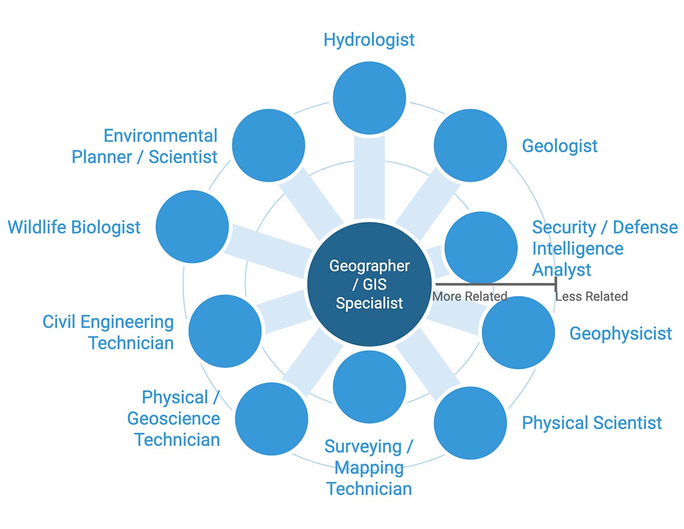
    Related Job Titles to Geographic Information Science, from BurningGlass.com (November, 2020).

    That is good news for graduate students, who can anticipate a positive GIS career outlook with opportunities to enter dynamic and lucrative positions. Here are some of the fastest-growing jobs in GIS and the skills students should develop to prepare for them:

    Request Brochure

    Fill out the information below to learn more about the University of Southern California’s GIS Graduate Programs and download a free brochure. If you have any additional questions, please call 213-325-2474 to speak to an enrollment specialist.

    University of Southern California has engaged AllCampus to help support your educational journey. AllCampus will contact you shortly in response to your request for information. About AllCampus. Privacy Policy. You may opt out of receiving communications at any time.

    * All Fields are Required. Your Privacy is Protected.

    1. Geographer

    Geographers study the earth’s surface, surveying how features form and change, the ways inhabitants navigate their environments and the effects of social, political and cultural norms. They gather and interpret data from a variety of sources, including field work, censuses, maps, photographs and satellite imagery. Their research involves observation, controlled experiments and surveys. They may then link their results to other fields of study, including economics, public health, politics and environmental science.

    The Bureau of Labor Statistics reported that the federal government employs 54 percent of geographers, but 12 percent work in architecture, engineering and related areas. In 2017, these professionals earned a median salary of $76,860. Although many people begin their careers in GIS with a bachelor’s degree, a master’s degree in GIS may help students bypass an entry-level position, change career paths or take on a leadership role.


    2. Cartographer/Photogrammetrist

    Cartographers and photogrammetrists both review geographic data to create and update maps. However, there are significant differences in their approaches. While cartographers strive to create informative maps that can be intuitively used for reference, photogrammetrists create models of the planet’s surface that can then be used to generate maps.

    Cartographers and photogrammetrists use advanced geospatial technology to create visualizations that provide valuable details and support strategic decision-making for purposes ranging from geology to marketing. Specialized maps can represent phenomena such as precipitation patterns or the damage after a natural disaster. The increasing impact of weather events like hurricanes and forest fires, is one reason why the need for cartographers and photogrammetrists is expected to rise in the near future.

    In fact, the BLS predicted this field will grow by 19 percent between 2016 and 2026, much faster than the average rate for all occupations of 7 percent. Cartographers can anticipate a salary of around $63,990. As with geographers, many cartographers and photogrammetrists work in local government, engineering, architecture and similar services.

    Related content: Learn About GIS Career Success Obtained by USC Graduates


    3. Urban/Regional Planner

    Urban/Regional Planner explaining insights learned from GISUrban and regional planners strategize land use to accommodate various populations. They record and analyze information from censuses, environmental studies and market research to help communities more effectively fulfill residents’ needs. Urban planners’ responsibilities may include helping to develop parks in urban areas, creating new options for homeless populations or working to make neighborhoods more attractive to businesses.

    These professionals use GIST software to visually interpret geographic and demographic information for planning purposes. For example, an urban planner may compare the geography of an area with its population density, then use the findings to design suitable infrastructure systems. Planners work closely with government officials, engineers, lawyers, real estate developers and architects.

    The median salary for urban and regional planners was $71,490 in 2017. The BLS expects the field to add jobs at a faster-than-average rate, with an anticipated growth of 13 percent through 2026. Most entry-level employees have a master’s degree and several hours of work experience in a related field.


    4. Surveyor

    Surveyors determine legal property boundaries, taking measurements for land transactions and engineering, construction or mapmaking projects. They use GIS software, among other methods and tools, to measure distances and angles with optimal precision. Data drawn from satellite imagery and GPS allows surveyors to create detailed maps and reports that guide planning and enable collaboration with specialists such as landscape architects, cartographers and civil engineers.

    According to the BLS, the median salary for surveyors in 2017 was $61,140 with a job growth rate of 11 percent resulting in a projected 44,800 new jobs by 2026. To certify the legal documents that set property lines or establish markings for construction projects, a surveyor needs a state license, obtained through a combination of education, work experience and testing. Each state has its own regulations, but a graduate degree may help to fulfill these requirements.

    Related Content: Discover GIS Salary and Future Growth Statistics


    About USC’s GIS Graduate Programs

    The University of Southern California offers a comprehensive selection of online and residential GIS programs. This includes both GIS master’s degrees and GIS graduate certificates. Click on the programs below to learn about our leading geographic information science education.

    GIS Master’s Degrees

    GIS Graduate Certificates

  5. A Coast-to-Coast Q&A with Michele Fong: From a Certificate to a Master’s in GIST

    Comments Off on A Coast-to-Coast Q&A with Michele Fong: From a Certificate to a Master’s in GIST

    Michele Fong Q&A
    Michele Fong (she/her) is a GIS analyst at engineering, architecture, environmental and construction services firm HDR. Living in Richmond, VA, Michele completed her online Graduate Certificate in Geographic Information Science and Technology (GIST) from the USC Spatial Sciences Institute in 2022. She tells us all, particularly on how this graduate certificate helped her land an internship and ultimately a full-time role at HDR as well as why Michele then decided to continue on and earn her M.S. in GIST.

    In this Q&A, Michele explains the factors that motivated her to delve deeper into geospatial problem solving and shares her experience of taking courses from the other side of the country.

    Request Brochure

    Fill out the information below to learn more about the University of Southern California’s GIS Graduate Programs and download a free brochure. If you have any additional questions, please call 213-325-2474 to speak to an enrollment specialist.

    University of Southern California has engaged AllCampus to help support your educational journey. AllCampus will contact you shortly in response to your request for information. About AllCampus. Privacy Policy. You may opt out of receiving communications at any time.

    * All Fields are Required. Your Privacy is Protected.

    Why did you decide to pursue graduate education in GIS?

    I decided to pursue graduate education in GIS because I wanted to pivot toward a technical career path. During undergrad, I took two GIS courses and thoroughly enjoyed working with ArcGIS, an interactive mapping software by Esri, and noticed it could be applied to various industries. My experience with the certificate program confirmed that I wanted to pursue a career in GIS and inspired me to continue to earn my master’s degree.

    What were your top considerations when comparing academic programs?

    I wanted to enroll in a well-established program with positive alumni reviews. There are so many online degree programs available, but I was looking for a program that offered both live class sessions and the opportunity to connect with classmates and professors. I also looked for programs with a broad range of courses that could apply to various industries and jobs.

    Why did you decide on the University of Southern California to complete your GIS graduate program?

    I decided on USC’s GIST certificate program because it offered multiple classes I was interested in. Since I earned my certificate through USC, I was able to apply to the master’s program smoothly. I also had the opportunity to connect with one of the alumni ambassadors. She told me about her time as an online student and her unique Catalina Island experiences sold me on my decision.

    What are some of the most interesting or useful concepts and skills you learned in the certificate program that you were able to apply to your work?

    The cartography skills I developed from my classes have helped me immensely, especially when creating static maps and web applications on the job. I learned that attention to detail is key and something to keep in mind in the workplace.

    Which concepts and skills do you hope to explore further in the master’s program?

    I want to further develop my GIS programming skills during my last semester of classes and hope to continue building these skills throughout the process of developing my thesis.

    Why did you decide to pursue your degree online?

    I’m from the East Coast, so pursuing an online degree was my most sensible option. The fact that I could have a set schedule, attend live classes and meet with professors made USC’s program the most appealing.

    Tell us about your interactions so far with the DEN@Dornsife platform.

    I’ve had three courses using the DEN@Dornslife platform, all of which have been great. In these courses, every module and assignment is organized properly, so we can easily connect with classmates using the discussion option. I also appreciate the “Work To-Do” list that has helped me keep track of due dates.

    What are your interactions with your faculty and with other students like? Do you feel connected to your classes and classmates?

    I have been able to attend live online classes, and the discussions have helped me better understand the material and feel connected with both my peers and professors. I also really enjoyed my time at Catalina and forged great bonds with my classmates during group projects.

    Did you use any of the student support offered to you? If so, what is your experience like?

    My enrollment specialist has been amazing; I reached out to her quite a few times with questions about class registration, academic records, etc. She’s always been great at getting back to me and helping me with any issues.

    What are your career plans? How will your USC education contribute to these plans?

    I am currently a GIS analyst at HDR, and I help support GIS mapping and application development efforts for transportation-related projects. HDR recently offered me the option to transition from an intern to a full-time GIS analyst role, and I’m positive my USC education thus far has played a huge role in building my skills up to this point.

    What else would you like to share?

    I highly recommend USC’s GIS programs for those looking.

    ABOUT USC’S ONLINE GIS GRADUATE PROGRAMS

    The University of Southern California offers a comprehensive selection of online GIS programs, including GIS master’s degrees and GIS graduate certificates. This gives our students the ultimate flexibility in tailoring their education for their career goals. Click on the programs below to learn about our leading geographic information science education.

    Online GIS Master’s Degrees

    Master of Science in Geographic Information Science and Technology
    Master of Science in Human Security and Geospatial Intelligence

    Online GIS Graduate Certificates

    Graduate Certificate in Geographic Information Science and Technology
    Graduate Certificate in Geospatial Intelligence
    Graduate Certificate in Geospatial Leadership
    Graduate Certificate in Remote Sensing for Earth Observation

  6. The Ultimate Guide to Navigating the Job Market as a GIS Professional

    Comments Off on The Ultimate Guide to Navigating the Job Market as a GIS Professional

    Building your professional network, maximizing your resume and researching market roles are important steps to take throughout your graduate education. Whether you’ve just begun researching online GIS programs or are approaching your final months at the USC Spatial Sciences Institute, understanding how to navigate the job market prepares you to find and acquire the job of your dreams upon graduation.

    We’ve provided a comprehensive guide to support prospective students, current students and alumni of GIS programs as they take steps toward finding new careers.

    Make the job search more effective by utilizing the career prep services available to students and alumni of the USC Spatial Sciences Institute.

    Contents

    Request Brochure

    Fill out the information below to learn more about the University of Southern California’s GIS Graduate Programs and download a free brochure. If you have any additional questions, please call 213-325-2474 to speak to an enrollment specialist.

    University of Southern California has engaged AllCampus to help support your educational journey. AllCampus will contact you shortly in response to your request for information. About AllCampus. Privacy Policy. You may opt out of receiving communications at any time.

    * All Fields are Required. Your Privacy is Protected.

    Network Like a Pro

    A strong professional network builds a foundation that can connect you to multiple employers and career opportunities. Additionally, a network of people from diverse areas of the GIS field enables you to share insights, advance your industry knowledge and even improve your professional skill set.

    One of the best ways to meet other GIS professionals and get vital industry resources is to join a professional organization. There are dozens of such organizations for GIS professionals, including:

    Many of these organizations also host events and conferences, allowing you to expand your network while learning about research and innovations in the field. Some of the top events in the industry include:

    Another great way to boost your professional network is to reach out to USC Spatial Sciences Institute alumni. Our alumni ambassadors are available to connect, offer advice and share their experiences in the GIS field.


    Build a Professional Presence Online

    Having a professional presence online communicates your skills and experience while simultaneously making you easily accessible to employers looking for new talent. If you haven’t done so already, take time to build a profile on LinkedIn, arguably the top professional social networking site. You can also post your resume to job recruitment sites such as ZipRecruiter or Indeed, share unique and engaging professional insights on social media, or build a website that acts as a central access point to all of your relevant professional information such as interviews, published research or a PDF of your resume.

    Here’s how to make the most of online networking:

    Optimize your first impression

    You want your online identity to be professional and verifiable. Use your real name (or the name associated with your professional experience), and make sure your contact information is easily accessible. You can put this information in a graphic header or set it aside in a dedicated link.

    Use a professional photo in your profile, preferably a headshot, and avoid selfies or low-quality photos. Images that aren’t your face make it harder for connections to verify your identity.

    Incorporating a brief headline can quickly show your value. If you opt not to use a header with your contact information, you can instead display an image related to GIS (perhaps one taken during a fieldwork excursion or related to your thesis) to represent your passion in the GIS field.

    Display your experience and education

    Amplify the experience and education sections of your online profile by highlighting your achievements alongside your responsibilities. Quantify the results of your efforts where applicable. Include links to projects you completed at work or while pursuing your graduate degree or certificate.

    Make your elevator pitch

    Use the About section of your LinkedIn or other profile to publish your elevator pitch. If you had 30 seconds to explain who you are and your value as a GIS professional, what would you say? Focus on your skills, unique accomplishments and goals.

    Get endorsed for your skills

    List your technical skills, like programming languages and various GIS tools, and your soft skills, like communication, collaboration and leadership. Your LinkedIn connections, including previous coworkers, classmates, instructors and clients, can rate your proficiency and leave recommendations that appear on your profile. These people may also be willing to provide quotes about their experience with you that you can add to non-LinkedIn profiles.


    Research Industry Trends

    Familiarize yourself with the various aspects of the GIS roles that catch your interest, including job responsibilities, salaries and work environments. All this information helps you find a role that suits your strengths and professional objectives.

    O*NET

    The Occupational Information Network (O*NET), developed for the U.S. Department of Labor, provides detailed information on hundreds of jobs across every industry. As you can see on the entry for Geographic Information Systems Technologists and Technicians, O*NET provides vital information like:

    • Alternative job titles to improve your job search.
    • Required skills, such as SQL, ArcGIS and cloud-based management.
    • Work activities and duties.
    • Experience, training and education needed.
    • Wage and employment data for specific geographic areas, drawn from the U.S. Bureau of Labor Statistics.
    • Related occupations.

    Create an Effective Resume

    Start with the right resume structure to provide the most relevant information to prospective employers. There are three main types of resumes, and each is best suited for professionals at different stages of their careers:

    • Functional resume: Also known as a skills-based resume, this format showcases skills rather than the depth of your work history. It includes a professional summary of your qualifications, experience and goals as well as work history entries that demonstrate translatable skills and value. Use a functional resume if you have employment gaps or are shifting from another career field to GIS.
    • Chronological resume: This resume emphasizes experience and career growth by listing prior jobs in reverse chronological order. Use this resume if you have GIS experience, either from internships or previous professional roles, and are applying for lateral positions or career advancement.
    • Combination resume: This resume includes a professional summary that lists your strengths, goals, skills and relevant experience, including internships, school projects, volunteer work or jobs in other industries. New grads with little or no GIS experience and those seeking entry-level GIS roles should use this resume format.

    Once you have the right resume structure, optimize the content by:

    • Starting every bullet or sentence in your job description with an action verb.
    • Emphasizing your accomplishments rather than your responsibilities.
    • Quantifying your achievements where possible to demonstrate the value you brought to each role.
    • Including skills and other keywords from the job posting to help your resume get noticed by automated Applicant Tracking Systems (ATS).

    The Spatial Sciences Institute prepares and distributes a resume book of our graduate students to leading GIS industry leaders each year. For more insight on building your resume, visit the Career Center channel for resumes, cover letters and curriculum vitaes.

    Current students can have their resumes reviewed through the USC Career Center or attend a resume workshop for help.


    Improve Your Interviewing Skills

    Prepare for interviews by researching common questions employers ask candidates for the positions you are pursuing. Glassdoor features interview questions for specific roles and organizations. You can also consult an alumni ambassador, your GIS instructors or the USC Career Center.

    The best way to improve your interview skills is to practice. The Career Center has many interview preparation resources for GIS students and alumni, including Big Interview, an AI interview practice tool that asks questions based on your industry, role and experience level.

    The STAR method

    STAR is a mnemonic device to help you structure your responses to interview questions. As you practice interviewing, try to incorporate the following into your answers:

    • A real-life or hypothetical Situation.
    • The Task or challenge at hand.
    • The Action you took (or would take).
    • The Results of your efforts.

    This method allows you to show your skills in action and illustrate how you solve problems in the workplace. You can also use the STAR method when completing the work history portion of your resume.


    Know How to Accept a Job Offer

    There are three key steps in the process of accepting an offer:

    1. Evaluating the offer to ensure a good fit.
    2. Negotiating salary.
    3. Accepting or rejecting the offer in a professional manner.

    Industry research should tell you whether the salary and benefits are competitive for the role and your qualifications. You can use your findings alongside your experience as leverage when negotiating the offer, which also demonstrates confidence in your expertise. Note that you can negotiate things other than salary and traditional benefits — you and your employer can come to a compromise on paid time off, flexible work options, professional development opportunities and more.

    Be aware of the expected start date and anticipated hours as you consider an offer — particularly if you are a student. Apply your time management skills and check your schedule to make sure you can handle the role alongside your schoolwork.


    Seek Help When You Need It

    The USC Spatial Sciences Institute is dedicated to helping graduate GIS students and alumni get the resources they need to succeed during and after their time in the program. If you have any questions about careers, resume services, networking events or other information regarding your future in the field, reach out to student success advisor Jocelyn Ward by calling (213) 235-2129 or emailing jw_097@usc.edu.


    About USC’s Online GIS Graduate Programs

    The University of Southern California offers a comprehensive selection of online GIS programs, including GIS master’s degrees and GIS graduate certificates. This gives our students the ultimate flexibility in tailoring their education for their career goals. Click on the programs below to learn about our leading geographic information science education.

    Online GIS Master’s Degree

    Master of Science in Geographic Information Science and Technology
    Master of Science in Human Security and Geospatial Intelligence

    Online GIS Graduate Certificates

    Graduate Certificate in Geographic Information Science and Technology
    Graduate Certificate in Geospatial Intelligence
    Graduate Certificate in Geospatial Leadership
    Graduate Certificate in Remote Sensing for Earth Observation

  7. Managing Your Time As an Online Student

    Comments Off on Managing Your Time As an Online Student

    Time management is the ability to organize responsibilities and allocate the appropriate time to complete tasks. When you’re effective at managing your time, you’re able to meet deadlines, increase your productivity, combat procrastination and reduce stress. As a student and professional, time management also helps you produce higher-quality work more consistently and make progress toward reaching your goals.

    Getting your GIS graduate degree or certificate online provides you flexibility to complete your coursework on your own time. But the open-ended nature of the graduate GIS programs at USC can become a source of worry for new students. Maybe, for example, you’re not yet sure when you’ll have time for readings and assignments between personal obligations and work. We’ve been there.

    Use these tips to help you boost your time management skills and balance your schoolwork with other priorities.

    9 Tips for Time Management:

    • Have a Planner or To-Do List.
    • Stick to a Schedule.
    • Block Out Time for Different Tasks.
    • Start Your Assignments Early.
    • Break Complex Tasks Into Smaller Chunks.
    • Make Your Workspace Distraction-Free.
    • Avoid Multitasking.
    • Try the Pomodoro Technique.
    • Ask for Help — USC Is Here for You.

    Request Brochure

    Fill out the information below to learn more about the University of Southern California’s GIS Graduate Programs and download a free brochure. If you have any additional questions, please call 213-325-2474 to speak to an enrollment specialist.

    University of Southern California has engaged AllCampus to help support your educational journey. AllCampus will contact you shortly in response to your request for information. About AllCampus. Privacy Policy. You may opt out of receiving communications at any time.

    * All Fields are Required. Your Privacy is Protected.

    Have a Planner or To-Do List

    Planners are a time-management pro’s best friend. Get a standard notebook planner or a digital planner to access on your phone or tablet. Then, use the calendar to write down every deadline, exam and meeting for each class, and use the weekly or daily layout pages to make to-do lists for each day. Both a planner and to-do list can help you visualize your workload, prioritize your tasks and stay organized.

    Stick to a Schedule

    Create a schedule that accounts for lectures, time to complete assignments, and opportunities to collaborate with classmates, and follow it week to week. This is key to staying engaged in your studies and getting the most from the program.

    “Treat school like it is your job,” says Jocelyn Ward, one of USC’s Student Success Advisors. “This is an investment in you and your future, so make sure you are making the time to be successful.”

    Here’s an example of how you might structure your week as an online student at USC. Be sure to adjust for any live or synchronous activities:

    • Mondays and Tuesdays: Focus on doing the readings, viewing media and recorded lectures, and taking notes.
    • Wednesdays and Thursdays: Post on class forums, start your assignments and begin replying to your classmates’ posts. Check in with your professors during virtual office hours to ask questions about the material or your assignments.
    • Fridays and Saturdays: Keep replying to classmates’ posts and chipping away at your assignments.
    • Sundays: Finish up your assignments and turn them in. Then, review the agenda for next week.

    Creating a regular schedule also helps you plan other parts of your life. For example, if you work a full-time job like many other online grad students, a set school schedule enables you to make time for friends, family and yourself.

    Ward reminds us that no two online students’ schedules are the same.

    “A schedule that works for you may not work for another, so take the time to figure out what is best for your success.”

    Block Out Time for Different Tasks

    Let’s say you have a work shift from 9 a.m. to 5 p.m. or a live lecture from 6 p.m. to 8 p.m. Block out time to work on your assignments the same way. Combine this strategy with your set schedule so you always have, for instance, 1 p.m. to 3 p.m. on Sundays to finish up all assignments, or spend 4 p.m. to 5:30 p.m. on Tuesdays and Thursdays working solely on assignments for your Spatial Data Science class.

    Use your planner or free tools like Google Calendar, iCalendar or Outlook Calendar to block out your week’s schedule. In addition, set a timer when you start your “shift” of coursework to alert you when you’ve hit your time limit.

    The key to making this strategy work is to set aside multiple blocks over the course of a few days for a single task before it’s due. By staggering time allocated to a single task, you can manage your day in such a way that other responsibilities are still addressed.

    Start Your Assignments Early

    Procrastination is a huge challenge for every student, but especially for those in grad school. Even if a project isn’t due for two weeks, you should start it as soon as possible so that you can complete it in chunks alongside other assignments. This approach lets you spread out complex tasks and avoid a time crunch.

    Starting assignments early also leaves you enough time to ask your professor questions, collaborate with classmates, do thorough research and put forth your best possible work.

    Dedicate smaller time frames, like 30 minutes to an hour, throughout the week for assignments due later, and schedule longer blocks for assignments with fast-approaching deadlines.

    Break Complex Tasks Into Smaller Chunks

    As a GIS student, you’ll have the opportunity to design, develop and execute your own GIS projects to demonstrate your understanding of GIS principles and your problem-solving skills. Once you get a big project, start breaking it down into smaller tasks. For instance, your first few tasks may be to review the project brief, go over questions with your professor, and do preliminary research.

    Make a plan that outlines each small step you must take to complete the full project. Estimate how long each stage should take you and when you should reach certain milestones, like completing your first draft. Then, assign yourself those smaller tasks over multiple days by blocking out time in your set schedule.

    Project management is one of the top GIS skills that employers look for in GIS analysts and other GIS professionals. If you’re able to improve your project planning skills during the program, you’ll be more effective when it’s part of your job.

    Make Your Workspace Distraction-Free

    Distractions break our focus, and we need focus to get things done. If you can, set up a dedicated workspace that’s just for you. If not, find a space that is as quiet and distraction-free as possible during your scheduled schoolwork time.

    Then, put away your cell phone and turn off notifications. Turn off the TV, and, if necessary, only put on music that will help you get in the productivity zone. Consider also downloading an app or browser extension that prevents you from visiting social media and other potentially distracting sites. These tools can help you stay focused and make the most of your time.

    Avoid Multitasking

    Contrary to popular belief, multitasking can make it harder to get tasks done in a reasonable time. When your attention is divided, you pay a “switch cost” — a reduction in your ability to focus on a task or do it correctly — each time you end one task and start another.

    A schedule that tells you when you should be focused on a certain class assignment or studying can help you avoid the temptation of multitasking.

    Try the Pomodoro Technique

    The Pomodoro technique is a time-management strategy that breaks down a large slot of time into manageable, focused work sessions called pomodoros. A single pomodoro can last anywhere from 15 to 30 minutes, after which you can take a short break to walk around, stretch, get some coffee or water, use the restroom, browse social media or decompress.

    This time management method is great for those who need breaks more often or who get easily distracted. It’s also a good method for working on tasks that don’t have deadlines, like studying or conducting research.

    What’s more, you can still use the Pomodoro Technique if you use the time-blocking method, too. You just work in short spurts during your longer “shift.”

    Ask for Help — USC Is Here for You

    Finally, don’t be afraid to ask for help. Balancing life, school, work and personal time is a normal challenge for all students, but especially online students. The faculty and staff at USC are here to support you by providing the advice and resources you need to succeed.

    “Be patient with yourself — it is going to take some time to get adjusted,” Ward says. “But once you find your groove, it is going to make things so much easier. Set a schedule, use a to-do list and make sure to arrange your tasks in order of importance!”

    You can reach out to Jocelyn Ward to get extra help balancing your GIS workload or ask questions about other aspects of being an online student. Email her at jw_097@usc.edu or call her at 213-235-2129.


    About USC’s Online GIS Graduate Programs

    The University of Southern California offers a comprehensive selection of online GIS programs, including GIS master’s degrees and GIS graduate certificates. This gives our students the ultimate flexibility in tailoring their education for their career goals. Click on the programs below to learn about our leading geographic information science education.

    Online GIS Master’s Degrees

    Master of Science in Geographic Information Science and Technology
    Master of Science in Human Security and Geospatial Intelligence

    Online GIS Graduate Certificates

    Graduate Certificate in Geographic Information Science and Technology
    Graduate Certificate in Geospatial Intelligence
    Graduate Certificate in Geospatial Leadership
    Graduate Certificate in Remote Sensing for Earth Observation

  8. Q&A with U.S. Marine Corps Imagery Analyst Jacob Spear

    Comments Off on Q&A with U.S. Marine Corps Imagery Analyst Jacob Spear

    We’re honoring the active service members and veterans in USC’s Geographic Information Science and Technology (GIST) graduate programs by sharing stories about their geospatial work in the military and experiences in the GIST programs.

    Online Master of Science in Human Security and Geospatial Intelligence student Jacob Spear has served in the United States Marine Corps for over eight years. Seeking a new challenge and the opportunity to give back to others, Spear began the HSGI graduate program in May 2021. His vision is to transition from active service to a career in geospatial intelligence.

    U.S. Marine Corps Imagery Analyst Jacob Spear

    Currently an Imagery Analyst, Spear analyzes geospatial imagery to provide high-quality intelligence to key decision-makers in the military. Below, Spear elaborates on why he chose the University of Southern California for his graduate degree and his experience pursuing the online M.S. in HSGI while working full-time.
    View our previous military student and alumni Q&As.

    Why did you decide on the University of Southern California to complete your GIS graduate program?
    I decided on USC because it’s a respected school with a well-regarded spatial sciences institute. The institute also offers a program specific to geospatial intelligence, which is unique compared to what is offered in other programs. Another important part of my decision was the in-person Catalina trip, as I wanted to have the experience to meet fellow classmates outside of a virtual environment.

    Request Brochure

    Fill out the information below to learn more about the University of Southern California’s GIS Graduate Programs and download a free brochure. If you have any additional questions, please call 213-325-2474 to speak to an enrollment specialist.
    University of Southern California has engaged AllCampus to help support your educational journey. AllCampus will contact you shortly in response to your request for information. About AllCampus. Privacy Policy. You may opt out of receiving communications at any time.

    * All Fields are Required. Your Privacy is Protected.

    What are some of the most interesting or useful concepts and skills you have learned in your program so far?
    Beyond deepening my understanding of geospatial intelligence, I have learned more about advanced remote sensing techniques and how to utilize them in combination with geographic information systems to better understand the world we live in.

    Tell us about your experience with the program’s online format through the DEN@Dornsife platform. Has it upgraded your learning experience?
    Since I’m in the military and stationed outside of Southern California, I’m only able to pursue my graduate education online. The DEN@Dornsife platform allows me to attend class when I can, which is important because my work schedule often changes and prevents me from being able to commit to a regular lecture schedule. Also, I’m able to refresh and review key concepts easily as the platform allows me to view lectures again.

    What are your interactions with your faculty and with other students like? Do you feel connected to your classes and classmates?
    I interact more with my classmates here than I have with other online school options. I have a better sense of community here and would feel comfortable reaching out to other students after graduation for advice, help or networking opportunities.

    Do you use any of the student support offered to you, such as academic advising or technical support? If so, what is your experience like?
    The academic advisors have helped me often by ensuring that I enroll in the courses I need to complete my degree. They’ve even worked with me to change my course schedule to ensure that I can complete all of my classes on the fastest possible schedule.

    What are your career plans? How will your USC education contribute to these plans?
    I plan to continue serving in the military until at least the end of my current contract. After serving, I want to pursue employment at the National Geospatial-Intelligence Agency, pursue a Ph.D., and eventually work in academia.

    What else would you like to share?
    I have enjoyed my time at USC and look forward to graduating in the winter. I often talk about my school experience with my peers and encourage them to pursue their higher education since there is never a time when you are too educated in your profession.


    About USC’s Online GIS Graduate Programs

    The University of Southern California offers a comprehensive selection of online GIS programs, including GIS master’s degrees and GIS graduate certificates. This gives our students the ultimate flexibility in tailoring their education for their career goals. Click on the programs below to learn about our leading geographic information science education.

    Online GIS Master’s Degrees

    Master of Science in Geographic Information Science and Technology
    Master of Science in Human Security and Geospatial Intelligence

    Online GIS Graduate Certificates

    Graduate Certificate in Geographic Information Science and Technology
    Graduate Certificate in Geospatial Intelligence
    Graduate Certificate in Geospatial Leadership
    Graduate Certificate in Remote Sensing for Earth Observation

  9. Student Interview with Cole Heap

    Comments Off on Student Interview with Cole Heap

    Student Experience: Uniting the Geosciences and Spatial Analytics

    USC Gis Student Cole Heap

    Cole Heap is a geologist at Aera Energy with 10 years of experience working in the geosciences. Realizing the benefits that would come from tackling projects and challenges with a spatial mindset, he decided to complete the online M.S. in Geographic Information Science and Technology(GIST). The program features coursework to help students learn to acquire, manage, analyze and share geospatial data — expertise that is useful for mapping the earth’s surface and many other applications.

    Below, Heap shares his experiences in the program, including the most useful skills he’s learned and how he’s already applying the knowledge he’s gained to his position.

    Request Brochure

    Fill out the information below to learn more about the University of Southern California’s GIS Graduate Programs and download a free brochure. If you have any additional questions, please call 213-325-2474 to speak to an enrollment specialist.

    University of Southern California has engaged AllCampus to help support your educational journey. AllCampus will contact you shortly in response to your request for information. About AllCampus. Privacy Policy. You may opt out of receiving communications at any time.

    * All Fields are Required. Your Privacy is Protected.

    Why did you decide on the University of Southern California to complete your GIS graduate program?

    Flexibility and the program experience really steered me towards the USC M.S. in GIST program. It is online — but without the “online” feel. There is also a week-long field component that really brings concepts together. As someone with a geology background, I found this type of knowledge application and experience essential!

    What are some of the most interesting or useful concepts and skills you have learned in your program so far?

    The projects are diverse. In one you may be assessing clusters of crime rates in LA, and in another you may be mapping the continental shelf in the Gulf of Mexico. But through each experience I have learned that there is more than one way to conduct spatial analyses. In this program, you learn the methodology to spatial modeling, how to make it your own and how to recognize possible pitfalls that may exist for your chosen method.

    What factors were most appealing to you about the online option? How has the online learning experience been?

    The flexibility led me to choose this program. I work full-time and have a family and other responsibilities, so I cannot just get up and leave to go to school. This online degree program is coming from a well-known university with instructors and researchers at the forefront of their fields.
    DEN@Dornsife, the course delivery platform, takes some getting used to after having used Blackboard, Canvas or any other online platform for education. I like that everything is all in one place for my classes. I also like having the ability to see that I have projects due and messages and updates from instructors.

    What are your interactions with your faculty and with other students like? Do you feel connected to your classes and classmates?

    The interactions have been great! I speak with peers outside of class and we discuss anything from projects to potential job opportunities. The faculty are always willing to meet and discuss questions or concerns. They are insightful, listen to you and offer great career advice.

    What are your career plans? How will your USC education contribute to these plans?

    I intend to continue in my current field of geology; however, I am already using many of the spatial analytics tools and skills I have learned in the program. I have been invited to help build up my peers’ skill sets by lending insight on how to better implement spatial tools in their workflows.


    About USC’s Online GIS Graduate Programs

    The University of Southern California offers a comprehensive selection of online GIS programs, including GIS master’s degrees and GIS graduate certificates. This gives our students the ultimate flexibility in tailoring their education for their career goals. Click on the programs below to learn about our leading geographic information science education.

    Online GIS Master’s Degrees

    Master of Science in Geographic Information Science and Technology
    Master of Science in Human Security and Geospatial Intelligence

    Online GIS Graduate Certificates

    Graduate Certificate in Geographic Information Science and Technology
    Graduate Certificate in Geospatial Intelligence
    Graduate Certificate in Geospatial Leadership
    Graduate Certificate in Remote Sensing for Earth Observation

  10. GIST in the Military: From the Air Force to the Space Force

    Comments Off on GIST in the Military: From the Air Force to the Space Force

    We’re celebrating our student and alumni veterans by sharing stories about their geospatial work in the military and experiences in the GIST programs.

    Jillian Combs began the online Master of Science in Human Security and Geospatial Intelligence (HSGI) in May 2019 with a mission: complete the program in just one year while also working full-time. Combs met that goal, graduating in May 2020, despite facing major life events along the way.

    Now employed by the United States Space Force, Combs is most appreciative of the skills she acquired in writing briefs, thinking critically and knowing how to recognize biases in data in the HSGI program. Below, she shares details on her favorite projects and program experiences, along with tips for anyone else who may be considering completing the HSGI program on a condensed timeline.

    Read our other recent Q&A with Army veteran and Graduate Certificate in Geographic Information Science and Technology (GIST) and Master of Science in GIST program alumnus Chris Sanders.

    View our previous military student and alumni Q&As.

    Request Brochure

    Fill out the information below to learn more about the University of Southern California’s GIS Graduate Programs and download a free brochure. If you have any additional questions, please call 213-325-2474 to speak to an enrollment specialist.

    University of Southern California has engaged AllCampus to help support your educational journey. AllCampus will contact you shortly in response to your request for information. About AllCampus. Privacy Policy. You may opt out of receiving communications at any time.

    * All Fields are Required. Your Privacy is Protected.

    eli ibanga

    How did you get involved with geospatial work in the military?

    I served 2.5 years active duty in the Air Force, and when I got out I wanted to return to a civilian position. I found and applied for a PALACE Acquire internship as an intelligence specialist. I was accepted at the Peterson Space Force Base location in Colorado Springs, Colorado, and started work there July 2021.

    Why did you select the University of Southern California’s M.S. in HSGI program among others that you may have been considering?

    I chose the HSGI program because I wanted a high-quality degree program that I could complete entirely online and within one year. The admissions staff was incredibly helpful and ensured every question and concern of mine was answered in a timely manner. I also liked how veteran friendly the program is, and that several of the faculty members had served in military intelligence positions.

    What was the online learning experience like for you?

    It was a bit of an adjustment learning to use Blackboard and the virtual desktop, but there were very thorough how-to guides to make the transition much easier. I also really appreciated how helpful and understanding the professors were if a technical problem – or even big life event – came up during an assignment. They were also incredibly easy to communicate with over email, and I never had a problem receiving help despite being an online student.

    How were your experiences with faculty, staff and fellow students?

    I had wonderful interactions with everyone throughout this degree. I really enjoyed the Catalina Island fieldwork excursion where I got to meet my classmates in person, as well as the GEOINT Symposium.

    I had four or five of the nine classes with one student. We became friends and even met up when I was in his city for a conference. I also keep in contact with several of my professors who helped me apply for a PhD program, and I have told them about my current job, as many HSGI students would excel in a similar position. I even ran into one of my capstone partners at a training event for my new job.

    How has the program benefited you?

    The alumni network has been wonderful to be a part of. The skills and knowledge I learned throughout the program have also been beneficial; the biggest advantage I have noticed in my new job is how comfortable I was starting the position, in reference to the Intelligence Community and many of the baseline methods used.

    What has been one of your favorite GIST projects to work on?

    I really enjoyed my capstone project, which involved helping to create a remotely piloted aircraft course to be taught at USC. I was able to utilize my military background and learn how to gather more real-time data.

    What would you like others to know about this program?

    This program is amazing and very doable on a condensed timeline, but you must be on top of your assignments and deadlines. I completed the M.S. in HSGI in a year by taking three classes every semester while working full-time, moving twice and getting a major surgery, but I had to be very vocal about my situation and make sure I was able to plan around some of the significant life events that came up. The professors were always there for me to ask questions. They were understanding when I was attending school related events, like the GEOINT Symposium and Catalina Island, allowing extensions on assignments so I could focus on gaining the most from those experiences.


    About USC’s GIS Graduate Programs

    The University of Southern California offers a comprehensive selection of online and residential GIS programs. This includes both GIS master’s degrees and GIS graduate certificates. Click on the programs below to learn about our leading geographic information science education.

    GIS Master’s Degrees

    GIS Graduate Certificates

  11. GIST in the Military: The Pervasiveness of GIS

    Comments Off on GIST in the Military: The Pervasiveness of GIS

    We’re celebrating our student and alumni veterans by sharing stories about their geospatial work in the military and experiences in the GIST programs.

    Army veteran and Graduate Certificate in Geographic Information Science and Technology (GIST) program alumnus Chris Sanders completed the certificate in 2018, but he didn’t stop there.

    “I felt that finishing the program out and getting my M.S. was the best thing for me both personally and professionally. It was a goal that I had set years before, and it was very important and fulfilling for me to complete that goal,” he says.

    Sanders completed the Master of Science in GIST program in 2020. In the following article, Sanders describes his positive experiences with faculty, staff and fellow students in the master’s and certificate programs, as well as his predictions for the future of GIS.

    Read our other recent Q&A with Air Force veteran and M.S. in Human Security and Geospatial Intelligence program alumna Jillian Combs.

    View our previous military student and alumni Q&As.

    Request Brochure

    Fill out the information below to learn more about the University of Southern California’s GIS Graduate Programs and download a free brochure. If you have any additional questions, please call 213-325-2474 to speak to an enrollment specialist.

    University of Southern California has engaged AllCampus to help support your educational journey. AllCampus will contact you shortly in response to your request for information. About AllCampus. Privacy Policy. You may opt out of receiving communications at any time.

    * All Fields are Required. Your Privacy is Protected.

    chris sanders

    How did you get involved with geospatial work in the military?

    As an airspace manager, I used software programs to ensure close combat and combat support missions were all properly sequenced within airspace.

    How do you use GIS in your current role?

    I’m a crisis response manager at Verizon. We use maps in several different ways, but primarily to manage our inventories of equipment and to coordinate our responses after a disaster to best assist our customers.

    Why did you select the University of Southern California’s programs among others that you may have been considering?

    After reviewing the colleges that offered GIS programs, USC’s was hands down the most comprehensive program.

    What was the online learning experience like for you?

    It was great because it allowed me to continue working. You have to have a certain level of diligence to make sure that you meet the course timelines and due dates. It’s very easy to fall behind if you don’t stay on top of things.

    How have the programs benefited you?

    They have given me the skills and knowledge I need to understand most GIS applications, from basic to advanced. I’m also able to understand if a program is at the right level for my team to use. Any salesperson will tell you their GIS software is what you need to get your job done, but actually being able to use that software and immediately have a grasp of what it can and cannot do is invaluable.

    What knowledge and skills did you acquire that you find especially valuable?

    I learned so much more about cartography and how to really read and understand a map; now I find myself critiquing any map I see. These cartography skills also come in handy with my career because I have to respond to areas hit by natural disasters, and being able to recognize an area that has been destroyed based off of topography and cartography is very helpful.

    What has been one of your favorite GIST projects to work on, either in USC’s programs or in your career?

    The Catalina excursion was one of the best times I’ve ever had working on a project. It was both a great learning experience as well as an opportunity to get to know some of my peers. The students and faculty made the time spent there memorable, and being on an island where you can snorkel and do other things in your free time is a definite plus.

    What would you like others to know about these programs?

    GIS, and the way these systems impact our lives, is only expanding. Knowing how data is used to make laws, conduct studies, and perform a census, among other things, is becoming more and more crucial. Understanding these systems is a skill that, in my opinion, is only going to become more of a “need” rather than a “nice to have.”


    About USC’s GIS Graduate Programs

    The University of Southern California offers a comprehensive selection of online and residential GIS programs. This includes both GIS master’s degrees and GIS graduate certificates. Click on the programs below to learn about our leading geographic information science education.

    GIS Master’s Degrees

    GIS Graduate Certificates