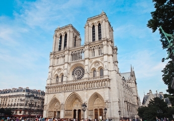
3D GIS and Mapping Will Be Crucial in Restoring the Notre Dame Cathedral
The fire that engulfed the Notre Dame Cathedral in Paris on April 15, 2019 is tragic, with early estimates putting the cost of rebuilding in the billions. While the event led to catastrophic damage, restoration efforts have a unique advantage in the digital age. The use of 3D GIS modeling and 3D GIS mapping software will be central to restoring this landmark.

Nearly four years before the fire, the late Andrew Tallon, a former professor in New York, used 3D GIS technology to create a detailed visual model of the Cathedral. An art historian, Tallon’s intention was to, “retrace…the story of the construction, transformation and reconstruction of Notre Dame.”
Using a “highly precise spatial map of over one billion laser-measured points,” Tallon worked tirelessly to reveal the eight centuries of architectural strife, construction and remodeling that have gone into maintaining this beloved structure. While his 3D GIS map reveals structural deficiencies, it also tells the story of generations of visionaries, builders and now geospatial technology professionals who have all worked to maintain this monument’s beauty.
Tallon wasn’t the only one to use 3D GIS modeling to map out the Cathedral, meaning that we have multiple, highly-detailed maps of what the structure was like before the fire. The community of artisans and architects that will have their hand in the dynamic reconstruction of the Notre Dame Cathedral is only set to grow, as France announced an international competition to redesign the Cathedral’s spire.
Request Brochure
Fill out the information below to learn more about the University of Southern California’s GIS Graduate Programs and download a free brochure. If you have any additional questions, please call 213-325-2474 to speak to an enrollment specialist.
Historical Restoration Using 3D GIS Technology
Restoring architectural gems with the use of 3D GIS technology is becoming more commonplace. When used in conjunction with building information modeling (BIM), 3D GIS data revolutionizes the accuracy and precision of restoration work. With these two technologies together, experts can better understand the buildings they work on, drawing insights that consider the architectural history of both the structure itself and the space in which it is built.
In the article cited above, we discuss how the use of BIM and 3D GIS was used to record and restore cultural heritage sites in Dublin, Ireland. The project resulted in a database of information that can be used to generate in-depth visualizations and guide tourists. 3D GIS technology is also being used prioritize the restoration of rural buildings in Spain and to create archaeological predictive models in Oregon.
How GIS Helps Us Understand Our Past and Build Our Future
The partial destruction of the Notre Dame Cathedral is devastating, but it also reveals a story of perseverance and optimism. Now that we have the tools to understand the culture and rich architectural history of structures like the cathedral at a far greater depth, modern restorers can honor the centuries of work that went into the monument before them.
The multi-disciplinary growth in the field broadens the demand for professionals who can aptly gather, manage and analyze geospatial data to develop valuable insights and revealing visualizations. As investment in more sophisticated 3D GIS technology and other tools grows, so will the opportunities for GIS professionals to help us understand the world around us, whether they’re helping us to understand the history behind a centuries-old monument, developing plans for the future of our smart cities or exploring one of the countless other applications of GIS.
About USC’s GIS Graduate Programs
The University of Southern California offers a comprehensive selection of online and residential GIS programs. This includes both GIS master’s degrees and GIS graduate certificates. Click on the programs below to learn about our leading geographic information science education.
GIS Master’s Degrees
- Master of Science in Geographic Information Science and Technology (GIST) – Online and Residential
- Master’s in Geodesign, Environment and Health – Residential
- Master of Science in Human Security and Geospatial Intelligence – Online and Residential
- Master of Science in Spatial Data Science – Online and Residential
- Master of Science in Spatial Economics and Data Analysis – Online and Residential
- Master of Arts in Global Security Studies – Residential
GIS Graduate Certificates
- Graduate Certificate in Geographic Information Science and Technology (GIST) – Online and Residential
- Graduate Certificate in Geospatial Intelligence – Online and Residential
- Graduate Certificate in Geospatial Leadership – Online and Residential
- Graduate Certificate in Remote Sensing for Earth Observation – Online and Residential


